
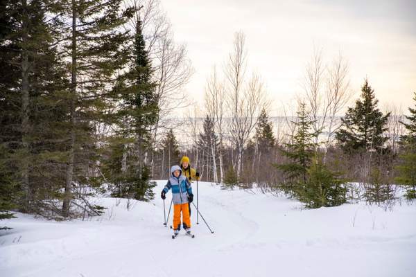
Cross-Country Ski Trail Conditions in Lutsen and Tofte
Lutsen and Tofte feature 153.2KMs of groomed cross-country ski trails on several different trail systems. Sugarbush Ski Trail Association, Norpine Ski Trail Association, Cascade River State Park, and Lutsen Mountains. Find complete cross-country ski trail conditions report here; updated weekly once the season begins.
-
Click to expand on the trail system for complete trail report and trail details!
-
- Sawbill Trail
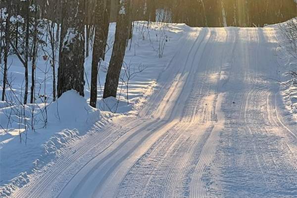
The Sugarbush Trail System is an extensive cross country ski trail network and a developing single-track mountain bike trail system in Northeastern Minnesota along the shores of Lake Superior. The system provides a variety of recreational opportunities in the Sawtooth Mountains…
TRAIL CONDITIONS
- Date: 3/15/2025
- Trail Base: 2"-6"
- Surface Conditions: transformed snow, icy and wet
- Snowfall Last 24 Hours: 0"
- Snowfall Last 7 Days: 0"
- Total Snowfall for the season: 53"
- Detailed Grooming Report: https://www.sugarbushtrail.org/ski_trails.php
Trail Conditions Update/Notes from the Sugarbush Trail Association: 3/15/2025: We've had rain and warm temperatures, which have deteriorated snow conditions. Water is also flowing in lower areas. It appears that we are heading towards the end of the ski season.
Firsthand Trail Reports: From skinnyski.com: 3/12/2025: Plenty of snow still hanging around. The skate deck is squishy and slow, but with the a dusting of fresh snow and more reasonable temps the past couple days. Classic tracks are icy and fast, but relatively free from debris and bare spots. (Tim Lupfer)
Firsthand Trail Reports: From skinnyski.com: 3/12/2025: Skied onion river, oberg, and to homestead. Really nice with the fresh snow. Oberg was a little bumpy, onion river was best. (Jacquelyn Bacigalupi)
The Oberg warming cabin is now open with a wood stove, tables, and chairs. Thanks to former USFS employee and local resident Tim Norman for getting it ready this year. Tim is actually the one who moved the cabin to this location. The cabin is a historic Ranger Station cabin built around 1920 and was located at Sawbill Lake. The one room structure was home and office for a Forest Service Ranger in the Sawbill area. Now, skiers and hikers can enjoy getting out of the cold and warm themselves by the fire.
Typical grooming schedule: Our budget allows for grooming the entire system on Thursday and/or Friday (evening) of each week, starting with priority trails. Touch-up on priority trails (as needed) Monday or Tuesday. (Schedule may be adjusted if there is new snowfall.) The Sugarbush Trail Association maintains 65 kilometers of cross country ski trails through beautiful and remote Forest Service land in the Lutsen-Tofte area, and has partnered to help develop nearly six miles of new single-track mountain bike trails with additional miles in the planning stage.
-
- Hansen/Hjemstad Rd.
The Norpine Trail System is 57km of machine-groomed X-C ski trails between Cascade River and Ski Hill Road and the Deer Yard Lake area. This system is described as Nordic skiing in alpine conditions due to the varied elevation changes throughout the system. This system is has…
TRAIL CONDITIONS
- Date: 3/24/2025
- Trail Base: 6-11"
- Snowfall Last 7 Days: 5-8"
- Total Snowfall:
- Detailed Grooming Report: https://www.norpinetrails.org/TrailsReport.html
Trail Conditions Update - From the Norpine Trail Association: 3/24/25
Deeryard Main Loop & Firetower groomed today. Trails at Deeryard are in great shape. Trails closer to the lake have not been recently groomed and should be considered "Ski at your own risk" due to considerable ice throughout. (posted by Adam Dettman from SkinnySki)
3/7/2025: Pioneer Loop and Deeryard Main Loop groomed Thurday, 3/6 for Ski North Ultra race. Grooming efforts have been otherwise stalled due to lack of snow. Use Caution.
Firsthand Trail Reports: From skinnyski.com: 3/7/2025: Skied the Massie and Hall loops starting around 11am this morning, and saw groomers out refreshing the skate deck on the race course. Conditions were crusty to icy, softening in the sunny spots by 1pm when we were wrapping up, but totally skiable and fast. Tracks were not set but mostly present and usable, but I'll probably skate later this afternoon. Maybe rock ski conditions for some folks, but the intermittent bare patches, rocks, and debris were very avoidable for a confident skier. I'd expect these are some of the thinnest and worst conditions up here right now, but still a fun rip! (Dan Petters)
Directions to Trailheads:
Deer Yard Lake Trailhead
144 Murmur Creek Rd
From Lutsen: At mile 101.7 on #61 turn on Cty Rd 7. Drive 1.9 miles, turn left on Cty Rd 44. Drive 0.6 miles, turn left on Cty Rd 45. Continue on Cty Rd 45 4.1 miles to Murmur Creek Rd (CR 45 takes a right turn at this intersection). Continue west on Murmur Creek road 0.7 miles, the trailhead is on the left at #144.
From Grand Marais: In town on Hwy 61 at mile 109.2 turn onto County 15 (5th Ave W). Drive up the hill on Cty 15 to Cty 7 and turn left. Drive west on Cty 7 for 5.2 miles to Cty 45. Turn right on Cty 45 and drive 5.0 miles to Forest Rd 332 (Murmur Creek Rd). Continue west on Murmur Creek Rd for 0.6 miles to the Trailhead Parking lot.
Lutsen Ski Hill Road Trailhead
Cty Rd #5
Turn off #61 at mile 90.1 onto Lutsen Ski Hill Road. Drive on Lutsen Ski Hill Road 1.2 miles to Norpine connector access trailhead on the right side of the road that is 0.1 mile before Mountain Inn. Parking is very limited.
Caribou Trail Trailhead
Cty Rd #4
Turn off #61 at mile 92.5 onto Caribou Trail. Drive up the Caribou Trail 1.4 miles to parking lot on the left. Accesses trail to Lutsen Mountain Ski Area to the west or Massie Loop to the east.
-
- 3481 West Highway 61
- (218) 387-6000
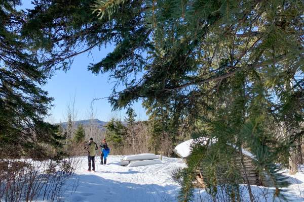
Cascade River State Park trails are consistent with the North Shore topography; cliffs intermixed with forest land. All types of wildlife can be seen along the trail. Ski trails range from easy to difficult. One loop is available for the less experienced skier. Trails connect to…
Cascade River State Park has 17 miles of groomed cross country ski trails. One beginner loop is available. Other trails are more difficult, and connect to other local trails outside the park. Trails are also available for hiking and snowshoeing. You can snowshoe anywhere in Minnesota's state parks and recreation areas, except on trails that are specifically groomed for another activity, such as skiing or snowmobiling.
Contact state park office for most current grooming report. Winter Office Hours: Friday- Sunday 10 a.m. to 2 p.m. but minimally staffed; call office for hours 218-387-6001.
This system can connect to the Norpine ski trail system as well as the Bally Creek ski trail system.
- Total Distance: 27.2 KM
- Difficulty Level: Beginner to Advanced
- Grooming: Tracked Classic
- Ski Pass Requirements: Skiers are required to have a Minnesota Ski Pass. They may be purchased online or in-person at most gas stations. The park office is open and ski passes can be purchased on Saturdays and Sundays from 9:00 a.m. to 3:00 p.m
- Parking & Trailhead Access: access trails via the Cascade State Park campground. State Park parking fees and rules apply.
- The enclosed picnic shelter becomes a warming house in the winter, and is heated weekends and holidays through the cross-country ski season. Buy firewood at the park office to heat the picnic shelter on weekdays. Unheated rustic shelters are located at backpack campsites along the trails.
- Ski passes are available outside the park office daily during the ski season.
- The campground is closed except for a few campsites. Water is available near the trailhead parking lot.
- Winter camping is available. Contact park for further details.
Firsthand Trail Reports: From skinnyski.com: 1/25/2025: Magical day in the mountains. Skied 30k from Cascade parking lot up Wolf Pack Run (had first tracks) to Bally Creek. And back down. Didn't see a soul until about 2k from Bally Creek where a nice couple was headed the other direction toward SHT crossing and Pike Lake Road. What an incredible, remote, beautiful trail. Plenty of snow, skier made tracks, good skis. Pretty fun going back down the 8k from PLR to park. 70% of return trip is either (a) point 'em or (b) a nice easy double pole to keep your momentum. Whole system end to end including Norpine to Lutsen looks to be in pretty good shape for 100k Ultra on March 8. (Kirk Geadelmann)
-
Trail Conditions
Sawbill Ski Trail is a 6k classic ski trail on a loop through the Superior National Forest. This is a privately maintained ski trail that we are happy to share with others. Park in the plowed parking lot and access the trail from the four-way intersection. No dogs or snowshoes please!
-
- 467 Ski Hill Rd
- (218) 663-7281
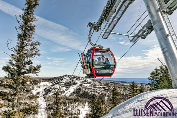
MINNESOTA'S MOUNTAIN VACATION Winter Lutsen Mountains offers the Midwest’s only true mountain ski area experience. Four interconnected peaks overlooking Lake Superior bring big mountain skiing with Up North authenticity. Whether you’re looking for a family ski holiday, a romantic…
Trail Conditions
Ullr Loop is not yet open for the season
- Date:
- Trail Base: "
- Snowfall Last 24 Hours:
- Snowfall Last 7 Days:
- Average Depth off the Trail:
- Trail Conditions Update/Notes -


Grand Marais Trail Conditions
Grand Marais has 52.9KM of groomed cross-country ski trails within minutes of downtown Grand Marais the Pincushion Mountain Ski Trail System, Bally Creek, and George Washington Pines. Find the complete cross-country ski…

Gunflint Trail Trail Conditions
Welcome to winter on the Gunflint Trail. Cross country skiing is one of the #1 activities on the Gunflint Trail in winter. Trail reports are updated weekly once the season begins, typically mid-November – April.